13 The two constellations
13.1 Where the cars went
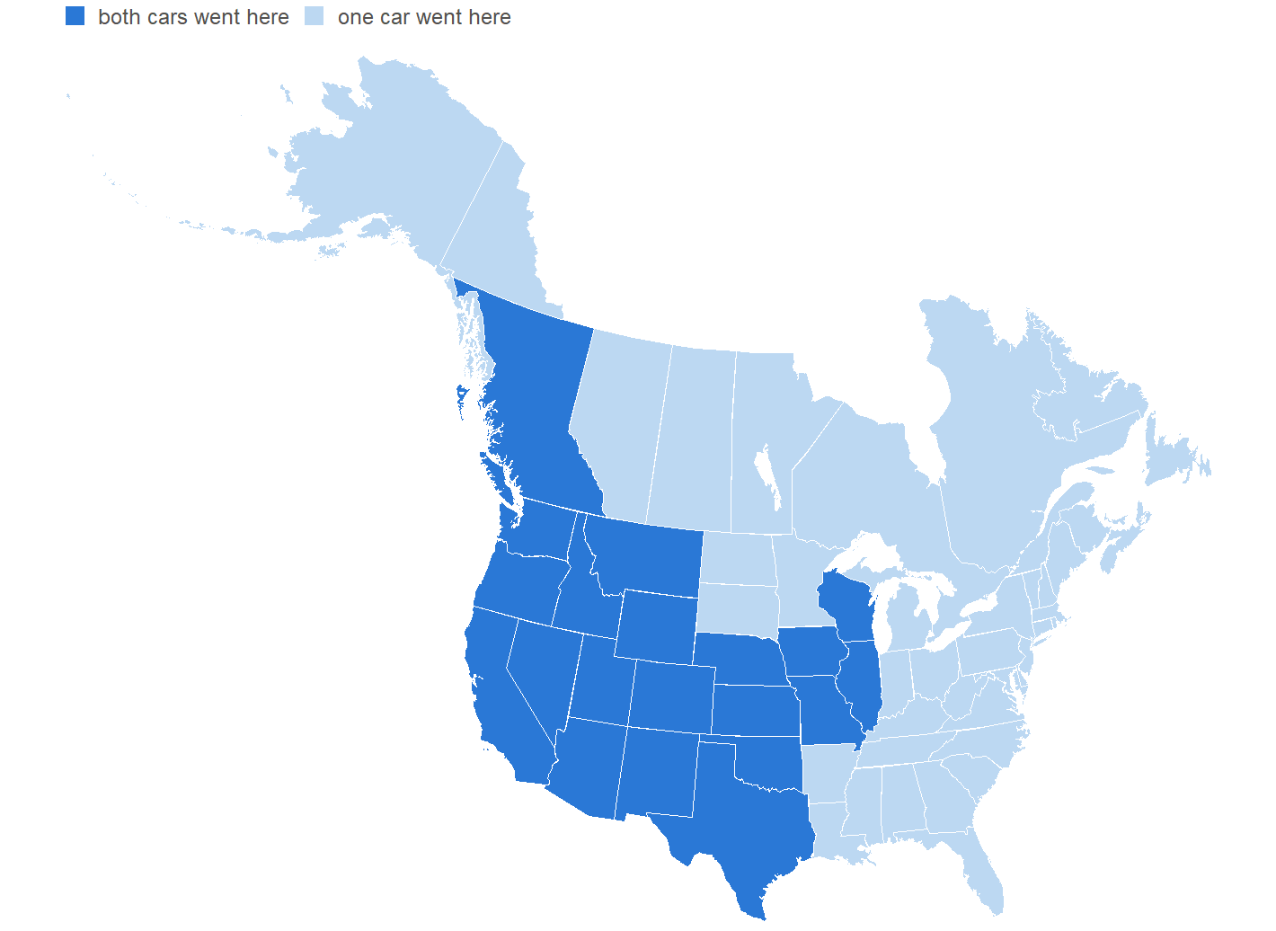
Sixteen years of driving make a map, and here it is.
49 states and 11 Canadian provinces and territories. That’s every one of the forty-eight, plus Alaska, plus a band of Canada that runs from Vancouver Island to Newfoundland. The only state that’s missing is the one the car lives in, and it went there by ship.
That’s the driving constellation, and it’s the picture I’d have drawn if you’d asked me in 2010 what this record was going to be for.
It isn’t, however, a picture of the fuel log. The fuel log is thinner than that, and the difference between the two is worth a section of its own.
13.2 The six the fuel log never saw
Leaving Hawaii aside, there are 6 states with no fill in either record. For a while I took that to mean the record couldn’t place the car in them.
That was wrong, and it was wrong in an instructive way: I was treating a hole in one instrument as a hole in the past. All six are settled, and not one of them is settled by the fuel log.
| State | Known from | The evidence |
|---|---|---|
| MD | the trip log | Frostburg, on the sheet photographed earlier in this book |
| VT | two of them | Hartland on the sheet, and a restaurant bill in Quechee |
| DE | arithmetic | a leg too short for any road that avoids it |
| RI | arithmetic | a leg on the Providence road, ending five miles from the line |
| SD | arithmetic | the most indirect stretch in sixteen years, out to the line and back |
| FL | a photograph | the car, at a named crossroads a mile inside the state |
Maryland and Vermont were driven through and never filled in, and the trip log has both. It only has them because of Chapter 9: before the scanning experiment the typed trip log ran to seven rows, and Frostburg and Hartland were sitting on paper in a box.
I’ll put a finer point on Maryland. The sheet photographed in Chapter 9, the one page of this record anybody will ever see reproduced, is Frostburg, and Frostburg is in Maryland. It’s where one of my meetings was. The single image in this book is a picture of the evidence for a state that’s blank on the map above, and I didn’t notice that until I drew the map.
And Vermont has a second witness, from an instrument that has nothing to do with cars. A credit card statement for the nineteenth of May 2014 carries a restaurant bill in Quechee, Vermont, which is a few miles from where I’d stayed. I took my friend to dinner, and the card company filed the receipt for its own reasons and kept it for eleven years. A fuel log records fuel and nothing else. A card statement records anything you paid for, which turns out to include being somewhere. Delaware, Rhode Island and South Dakota came back by arithmetic, and Florida by a photograph of the car at a crossroads a mile inside the line. Chapter 14 takes all four apart properly, because how a record gives back what it never recorded is a whole argument and not a footnote.
13.3 The absences all have mechanisms
Here’s what I’d add now that I’ve seen the map, because the table above makes these look like failures of record-keeping and they aren’t.
Every one of those six is a stretch where there was no reason to buy fuel, and in most of them no opportunity either. Vermont was a friend’s house a few miles over the line, and I got there by following him home from his office in New Hampshire: no stations on that road, and no stopping anyway, because I’d have lost him. The card statement caught the dinner because dinner is a thing you stop for. The fuel log caught nothing because fuel was not. South Dakota was a dash north to the line and straight back. Florida was a few miles into the panhandle and a turn around.
A fuel log doesn’t record where a car went. It records where a driver bought gas, and those are the same map only when the trip is long enough and ordinary enough to need one. The six holes are the places where the journey and the transaction came apart.
I believe in being strict with the data. But circumstances that are clearly explained do count, and every one of these has a circumstance rather than an excuse. The strictness is in demanding the explanation, not in refusing to hear it.
So the honest total is not the map’s total. 49 states, which is every one you can drive to. Hawaii is where the car lives, and it went there by ship.
13.4 The second car added nothing
Here’s a result I didn’t expect and had to check twice.
Creamsicle drove 19 states in its three years. Every single one of them was already TwoRed’s. Not one new state, a decade later, in a different car, from a different starting point, on what I’d have described as completely different trips.
The only ground the two cars share outside the United States is British Columbia, and they got there in opposite ways. Creamsicle bought three tanks on Vancouver Island. TwoRed crossed it twice and never bought anything. Coming off the ship at Haines there’s exactly one road north, and it runs through British Columbia before it reaches the Yukon: it’s a short enough stretch that the question of fuel never came up. And I clipped the corner of the province again coming off the Canadian plains.
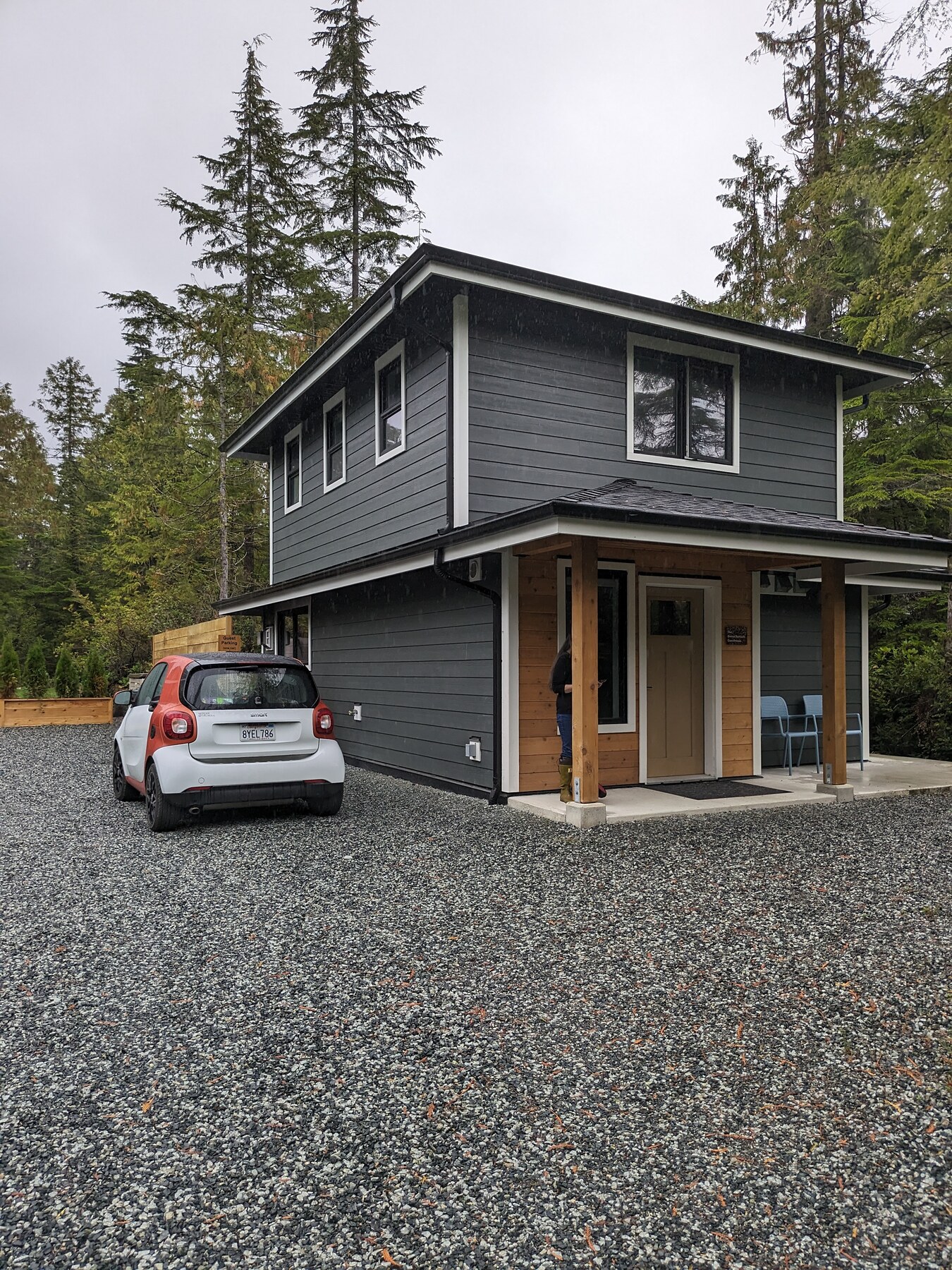
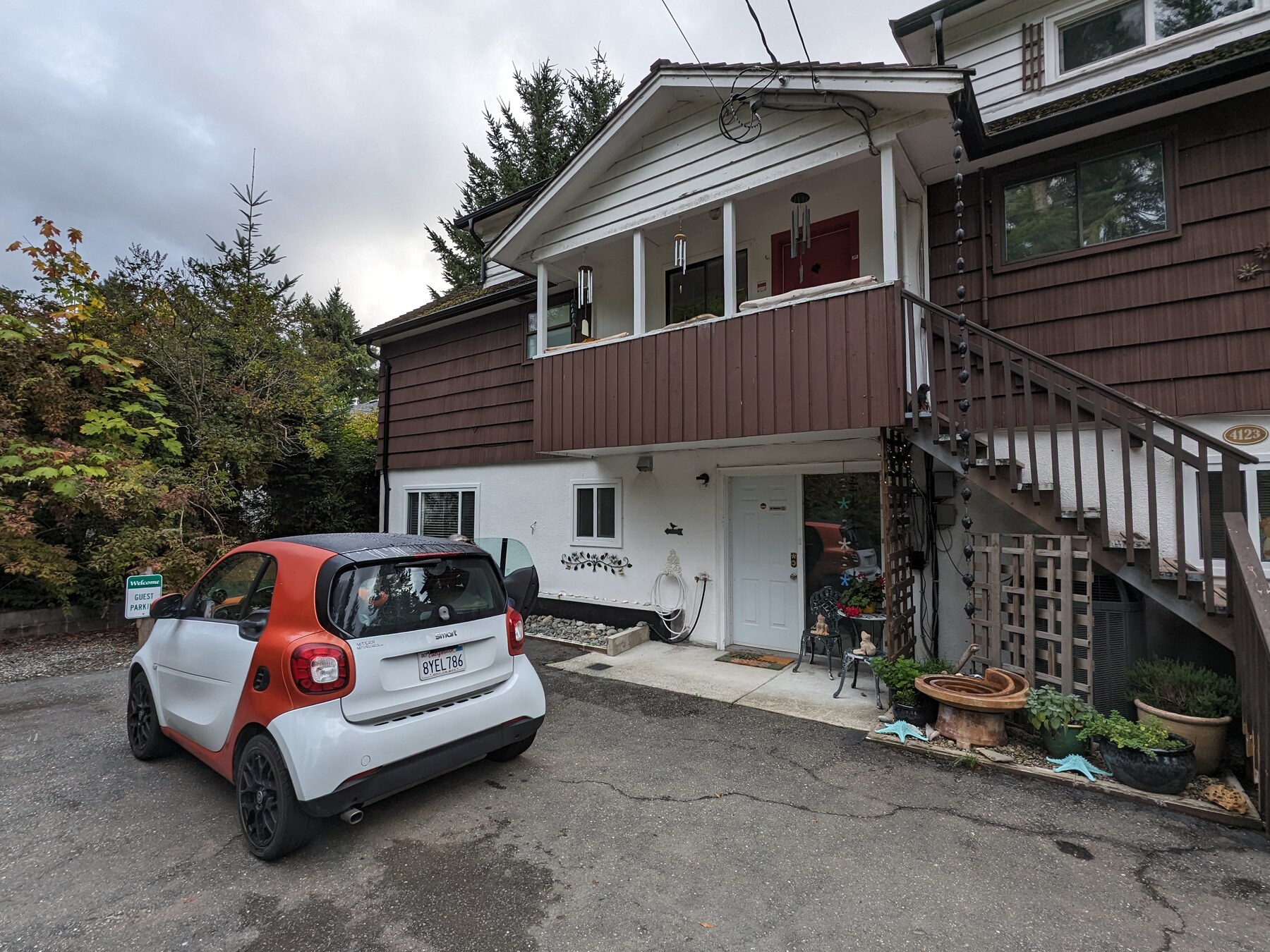
Prince Edward Island is the same story with a different receipt. We crossed on the Confederation Bridge and left by the ferry to Pictou, and no tank was bought on the island. What proves it is a card statement again: a motel bill at Murray Harbour, and the ferry booking itself. That makes eleven provinces and territories, and the fuel log knows about ten of them.
Chapter 11 found the two cars four tenths of a mile per gallon apart and called the car a constant. The map says the same thing about the driver. Ten years, a different vehicle, and I went back to the same country.
13.5 The same map, one dot at a time
The choropleth says where the cars got to. It can’t tell you anything about how they got there, though, because a filled state’s a filled state whether you crossed it once or lived in it.
So here’s every fuel stop both cars ever made, placed.
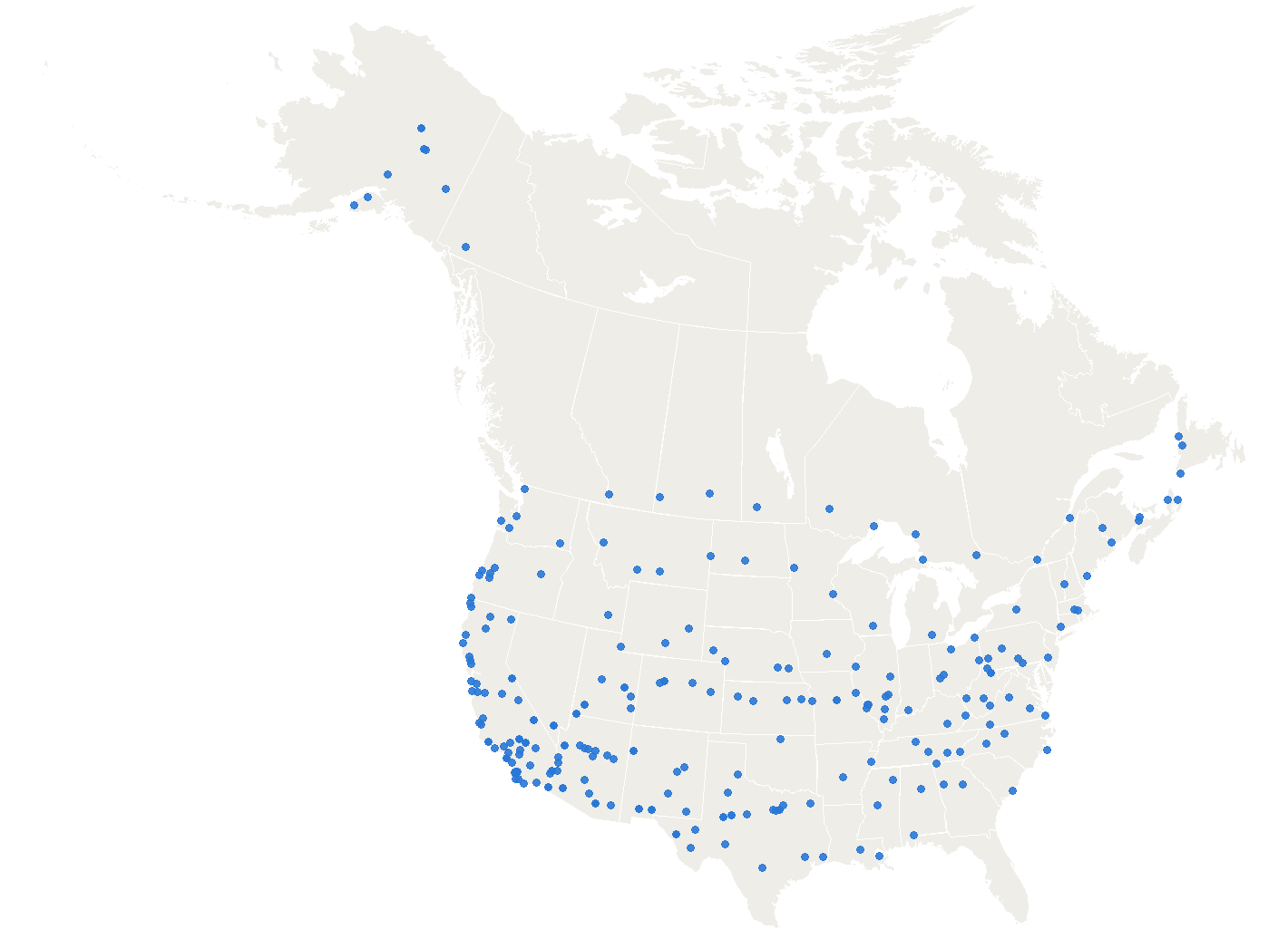
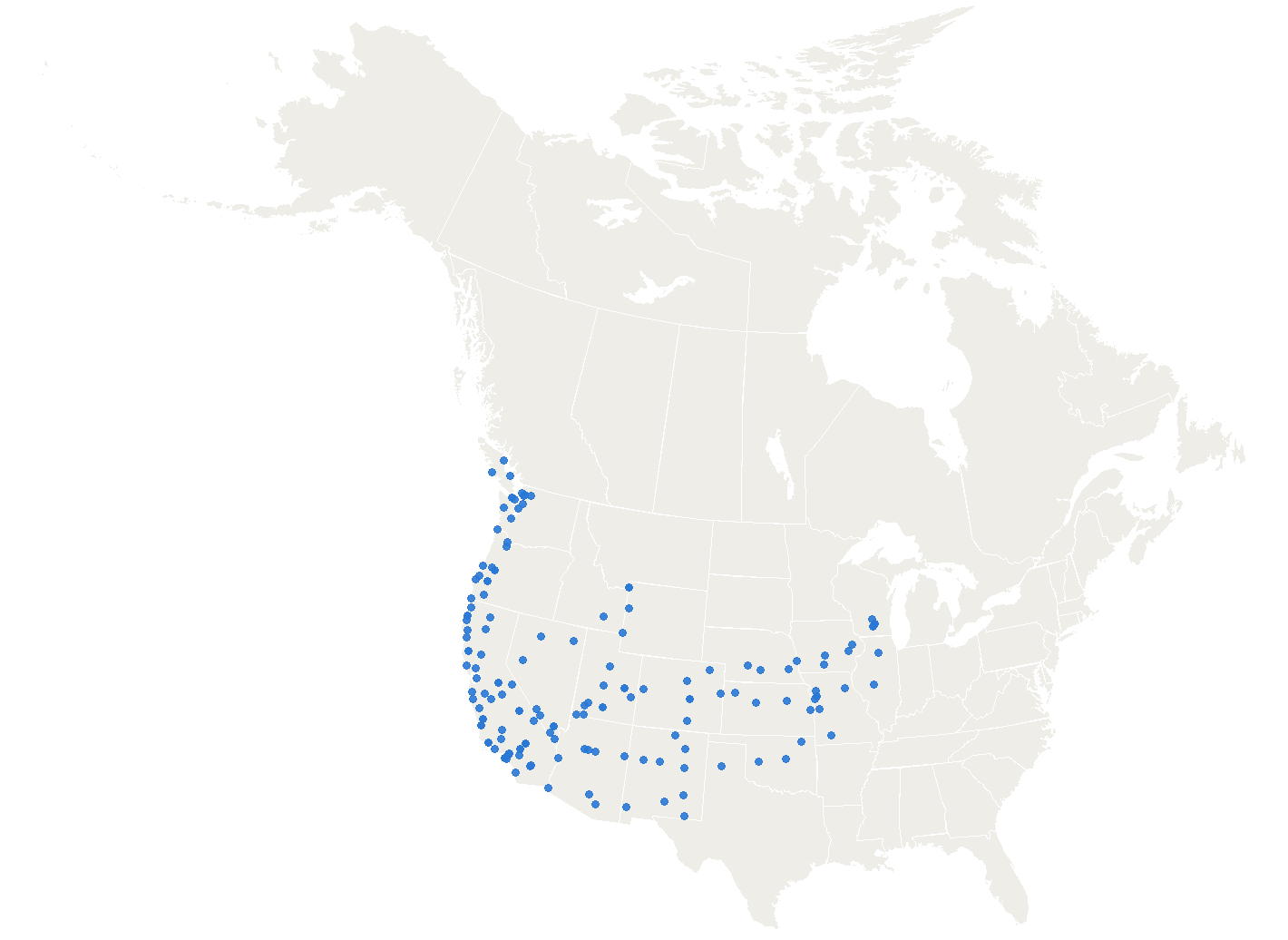
Put those two beside each other and something falls out that neither the choropleth nor the cost chapter could show. Chapter 11 found the two cars four tenths of a mile per gallon apart and called the car a constant. The choropleth found no new states in the second car and said the same of the driver. These say the trips were nothing alike. Same person, same kind of machine, same continent, and one of them’s a set of long horizontal strings while the other’s a coastline and a couple of corridors.
13.6 What a dot is, and what it isn’t
Now the caution, because the spacing in those figures is the first thing anybody will try to read.
A dot is not a day. It’s a transaction, and they only line up when the day happened to need exactly one tank. 28 percent of TwoRed’s fueling days carry more than one fill, and 38 percent of Creamsicle’s. The most in a single day is 3.
So the gap between two adjacent dots is a floor on how far the car went that day, and never a reading of it. Where the beads run evenly across the prairie you’re seeing a tank’s range and a driver’s habit tangled together, and Chapter 5 is the chapter that pulls them apart properly, with a clock and an odometer rather than with a picture.
What the dots do show honestly is reach and density. Where they crowd, the car’s working near home or in traffic. Where they string out, it was crossing something. And the one place they stop entirely, in the middle of the Gulf of Alaska, is Chapter 7: four days of movement and no transaction at all, which is this book’s whole argument compressed into a blank patch of ocean.
13.7 The map nobody draws
Now the other constellation, and this is the one I’d never have thought to look for.
From the first logged leg to the last is 2,209 days. The car was driven on 139 of them.
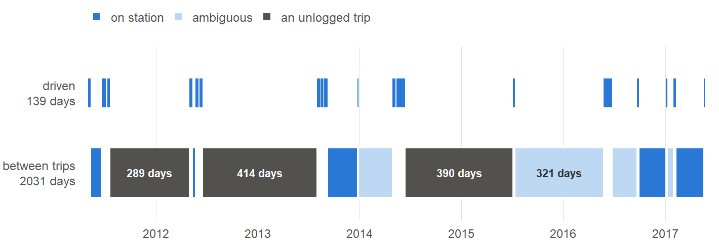
6.3 percent. Everything in this book, every long day and every road and every argument about fuel economy, comes off the thin blue marks in the top row of that figure. The other 91.9 percent is the bottom row, and the bottom row is a car sitting still in somebody’s garage.
That’s what a mainland car kept from Hawaii actually is. It’s a parked car with 139 exceptions, and Chapter 3 is the chapter about the real problem, which was never driving and always storage.
The longest single interval is 414 days, after the 2012 Frostburg trip. Fourteen months. The car sat, somebody’s garage held it, and the next sheet picks up as though nothing had happened.
13.8 Except that three of those gaps are lying
Look at the dark bands in that figure, because they’re the reason the parking map can’t just be read as parking.
Three of the twelve intervals carry more than fifteen hundred miles on the odometer. Between them they hold 12,371 miles that the trip log has nothing whatever to say about. That isn’t a car on station. That’s a trip nobody wrote down.
This is Chapter 4’s finding arriving from a completely different direction. There it was Kim’s own list of fourteen expeditions against thirteen logged trips. Here it’s the odometer, which cannot be argued with: 15,999 miles happened between the logged trips, against 41,163 inside them.
So the honest reading of that bottom row is three-way, and the figure colors it that way. Some of those intervals really are a car under a tarpaulin. Some are ambiguous. And three of them are journeys that left no trace except a number going up.
13.9 Where it actually slept
The one thing neither figure can show you is the part that mattered most at the time.
The parking constellation has names, and they aren’t in the data. A colleague’s farm outside Eugene. A car wash in St Louis with a garage nobody was using. My niece’s driveway at Mentone. A motel in southern California. A cousin’s space in Torrance, which we had to clear out before the car would fit. Every one of those came out of a conversation, and Chapter 3 tells the story of how each was found.
I could put dots on a map for those. I’m not going to, because it would be a map of five things I remember rather than a map of anything the record holds, and this book has been careful about that distinction for twelve chapters.
What the record holds is the shape: long stillness, punctuated. What I hold is the list of people who made the stillness possible.
13.10 Two pictures of the same car
Put the two constellations side by side and they disagree about what this car was.
The driving map says a continental vehicle: 49 states, 11 provinces and territories, the Arctic, four crossings, and a coastline at each end. It’s the map I’d show somebody who asked what we did with a Smart car.
The parking timeline says a car that sat still 92 percent of the time and was driven on fewer than a hundred and fifty days in six years.
Both are accurate and neither is the answer. The first map is what the car was for. The second is what owning it was actually like, and the second is the one that explains the first: the stillness is what made the driving possible. A car parked free in a friend’s garage for fourteen months is a car you can fly to and drive across a continent. That was the arrangement, and the arrangement is the story.
The fuel log drew the first map without being asked. The second one had to be gone looking for, and it took the odometer, twelve gaps and a lot of arithmetic to find a picture of a car doing nothing at all.